The integration of spatial thinking into science curriculum is a natural fit. Many learning activities lend themselves to spatial thinking. The example shown requires spatial visualization. In this case, students were asked to construct the blades of a windmill in order to turn the axle and pull up a cup full of washers. To be successful, students needed to visualize how the air currents would flow across the blades of their windmill. Aligning the blades so the flat side is facing the air current does not turn axle nor does turning the blades so the edge is facing the current. Students have to realize that the blades must be an an angle. Optimizing this angle produces greater rotation strength.

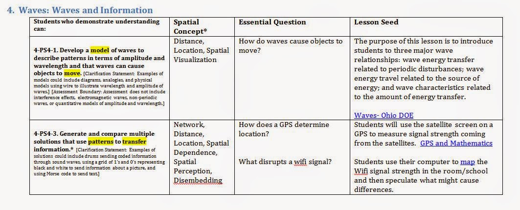
The primary difficulty of integration is not finding activities that require spatial thinking. There are plenty of rich science activities that are dripping with spatial connections. The problem is determining the developmental appropriateness of these activities that has slowed many efforts at integration. To overcome this dilemma and start the integration process, a matrix was created (sample at the end of the document). This matrix listed each of the elementary performance expectations (PE) in grades kindergarten through grade five (ages 5-10 respectively) of the NGSS. Spatial vocabulary within each PE is highlighted. Using this as a starting point each PE was classified using the lists of spatial thinking skills below.
|
Abstract Cognitive Skills
|
Geospatial Skills
|
|
|
If you are interested in receiving the fall "Next Generation Science Standards Spatial Integration Matrix" please contact me and I will be happy to email it to you.
Eric, this is very interesting. I teach physics at the University of New Hampshire, and am working with local schools on redesigning their science curricula to focus more on skill building, and teaching through inquiry and play-based learning. I place a heavy emphasis on building reasoning skills (in what I want schools to do, as well as what I do with my physics students in my university classes) - in particular deductive and spatial reasoning. I'd love to see your Spatial Integration Matrix for more ideas on integrating spatial reasoning with the Next Gen Science Standards. Could you email it to me at msbriggs at unh dot edu ? Thanks!
ReplyDeleteHi Eric,
ReplyDeleteThank you for this blog post. It is fanscinating to read your perspectives on how spatial thinking is embedded within NGSS, particularly within the SEP's. I am currently a Grad Student in Natural Science Ed and am really interested to explore this connections further, especially invesitigating connections within the realm of geospatial understanding. Would you be willing to send along a copy of your integration matrix? Thanks again for all your work!
Great and that i have a swell provide: What Does A Full House Renovation Cost home remodel
ReplyDelete