Showing posts with label Spatial. Show all posts

Saturday, September 6, 2014

A Very Spatial Opportunity

Well, one unit down and eight to go.  The first "official" NGSS unit is loaded into our learning management system.   The unit is based on the kindergarten "Interdependent Relationships in Ecosystems" performance expectations.  As you saw from the previous post, students learn about the Baltimore Checkerspot and its dependence on the White Turtlehead.  As part of the performance assessment, students have to locate a place on their schoolyard or community where they could plant the White Turtlhead.  To do this, the teacher gives students a printed copy of map generated by a simple mapping application I created using ArcGIS Online.

Shown below, the teacher can choose to use the aerial view or an abstracted view depending on the level of detail available.  All they need do is slide the bar in the middle back and forth to see what they want.


Developing maps and apps like this are available to every school across the U.S. because of the ConnectED initiative launched by the Whitehouse last year.  These are powerful tools.  In years past, these tools were confined to complex desktop applications, but the cloud movement has pushed a lot of their capacity to the online world.  Everyday, new maps and applications are created by users all over the world.  These can be brought into your classroom and used by your students to explore BIG DATA in unimaginable ways.  What is really amazing is that students can be the creators of these maps and applications as well.  

To get started, go to the ConnectED website and sign up for an account.  I would also recommend visiting the Esri EdCommunity page.  You will quickly find out that you are not alone.  If you need help, you should find the closest GeoMentor to you.  These are GIS zealots who love working with GIS and with kids (I have a dot on the map myself).  

Good mapping! 

Saturday, April 26, 2014

What Is So Spatial About the NGSS? A Curriculum Steeped in Spatial Thinking (Part 3)

In 2006, Learning to Think Spatially was published by the National Research Council.  Among its six recommendations was for the creation of spatial thinking standards based on existing content standards (National Research Council, 2006).  The goal is to allow students to develop spatial thinking in the context of relevant content.  While spatial standards have not been developed, current standards can be mined for spatial opportunities.  The Next Generation Science Standards (NGSS) offer a unique opportunity to develop spatial thinking in the context of a STEM education.

The integration of spatial thinking into science curriculum is a natural fit.   Many learning activities lend themselves to spatial thinking.  The example shown  requires spatial visualization.  In this case, students were asked to construct the blades of a windmill in order to turn the axle and pull up a cup full of washers.  To be successful, students needed to visualize how the air currents would flow across the blades of their windmill.  Aligning the blades so the flat side is facing the air current does not turn axle nor does turning the blades so the edge is facing the current.  Students have to realize that the blades must be an an angle.  Optimizing this angle produces greater rotation strength.


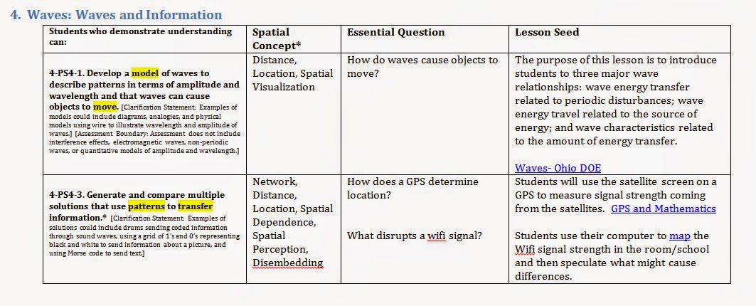
The primary difficulty of integration is not finding activities that require spatial thinking. There are plenty of rich science activities that are dripping with spatial connections.  The problem is determining the developmental appropriateness of these activities that has slowed many efforts at integration.  To overcome this dilemma and start the integration process, a matrix was created (sample at the end of the document).  This matrix listed each of the elementary performance expectations (PE) in grades kindergarten through grade five (ages 5-10 respectively) of the NGSS.  Spatial vocabulary within each PE is highlighted.   Using this as a starting point each PE was classified using the lists of spatial thinking skills below.

Abstract Cognitive Skills
Geospatial Skills
  • mental rotation
  • disembedding
  • visualization
  • perception
  • perspective taking

  • location
  • distance
  • region
  • network
  • overlay
  • scale
  • heterogeneity
  • dependence
  • objects
  • fields


Spatially focused essential question were developed and used as a filter for creating lesson seeds.  Lesson seeds consist of a broad overview of an activity idea and, where appropriate, associated resources.  Using this method, 62% of the PEs had spatial connections. Work will continue to expand on this initial analysis to broaden the scope of spatial connections.  This document will be used as a guideline for curriculum developers as they create a full elementary science curriculum aligned to the NGSS.


If you are interested in receiving the fall "Next Generation Science Standards Spatial Integration Matrix" please contact me and I will be happy to email it to you.  

Monday, April 21, 2014

What Is So Spatial About the NGSS? (Part 2)

During my last post, I laid out my argument for why we should think about the NGSS in spatial terms.  So now the obvious question is "So what?".  Why should we teach our students to think spatially?  Can it even be done?  Aren't these abilities set at birth?  


The ability to conceptualize the world in spatial terms has been strongly linked to success in science, technology, engineering, and math (STEM) related careers. A longitudinal study published in 2009 (Wai, 2009) details 50 years of research that solidifies this relationship. It showed that students with high spatial 
ability tended to choose STEM related careers at a very high rate.  As with many intellectual abilities, the perception that spatial ability is a fixed set of mental attributes has been overturned. Several studies have shown that a  student’s spatial ability can be cultivated through practice and meaningful application (Lee, 2009; Lubinski, 2010; Levine, 2005; Sorby, 2006) . However, spatial thinking has been largely ignored by public education with a focus on verbally or lecture based instruction being the norm. When spatial thinking is discussed, it is often maligned as a skill set relegated to trades and industries (i.e. carpentry, plumbing, welding, masonry, automotive repair) and not worthy of intellectual pursuit. However, some of the best minds of our time can trace their successes to the application spatial thinking. Albert Einstein once said that “The words or the language, as they are written or spoken, do not seem to play any role in my mechanisms of thought” and later concluding that his thoughts “are more or less clear images.” Nikola Tesla, a dynamic inventor who created the basis for alternating current, was rumored to be able to mentally build his inventions and visualize the working parts (Chandrasekhar, 2006). The reality of DNA’s double helix could not have been conceptualized except for the spatial cognition of Watson and Crick. However, as can be deduced from the examples given, there is a perception that ability to conceive of objects and their relationships in space is a white male dominated trait. This then begs the question of whether underrepresented populations (female, African-American, and Hispanic) in the STEM fields possess the capacity for spatial thinking and if so, what hinders its expression?

Several recent studies have concluded that the limiting factor influencing success in STEM programs regardless of sub-group is a lack of access to spatially related activities (Ault, 2010; Dixon 1995; Sorby 2012; Study 2004). Given the opportunity to think spatially, underrepresented populations perform as well as majority populations. It can therefore be speculated that the achievement gap cannot be overcome until the opportunity gap is overcome.


Ault, H., & Samuel, J. (2010). Assessing and Enhancing Visualization Skills of Engineering Studetns in Africa: A Comparative Study. Engineering Design Graphics Journal, 12-20.
 
Chandrasekhar, R. (2006, August 27). Chandrasekhar. Retrieved May 5, 2011, from Reflections on the Mind of Nikola Tesla: http://www.ee.uwa.edu.au/~chandra/Downloads/Tesla/MindOfTesla.html
 
Dixon, J. K. (1995). Limited English Proficiency and Spatial Visualization in Middle School Students Construction of the Concepts of Reflection and Rotation. The Bilingual Research Journal, 221-247.
 
Janelle, D. G. and M. F. Goodchild (2011). Concepts, Principles, Tools, and Challenges in Spatially Integrated Social Science. In Nyerges, T.L., H. Couclelis, and R. McMaster (Eds.) The Sage Handbook of GIS & Society. Sage Publications. pp 27-45
 
Lee, Jongwon; Bednarz, Robert. Effect of GIS Learning on Spatial Thinking Journal of Educational Psychology. v33 n2 p183-198 May 2009
 
Lubinski, D. (2010). Spatial ability and STEM: A sleeping giant for talent identification and development. Personality and Individual Differences, 344–351.
 
National Research Council.  Learning to Think Spatially: GIS as a Support System in the K-12 Curriculum. Washington, DC: The National Academies Press, 2006. 1. Print.
 
Susan C. Levine, Marina Vasilyeva, Stella F. Lourenco, Nora S. Newcombe, and Janellen Huttenlocher.  Socioeconomic Status Modifies the Sex Difference in Spatial Skill Psychological Science November 2005 16: 841-845, doi:10.1111/j.1467-9280.2005.01623.
 
Sorby, S. Gender Differences in Spatial Reasoning Skills and Their Effects on Success. http://www.edweek.org/site/News/Eweek/2006_marathon/BuildingSkills_2.ppt
 
Sorby, S. (2012). AC 2012-3305: Spatial Skills Among Minority and International Engineering Students. American Society of Engineering Education.
 
Study, N. E. (2004). Assessing Visualization Abilities in Minority Engineering Students. American Society of Engineering Education Annual Conference & Exposition (p. 11). Petersburg: American Society for Engineering Education.
 
University of Redlands. (2013). About LENS. Retrieved November 25, 2013, from LENS: http://lens.spatial.redlands.edu/?page_id=1118
 
Uttal, D. H., Meadow, N. G., Tipton, E., Hand, L. L., Alden, A. R., Warren, C., & Newcombe, N.S. (2012, June 4). The Malleability of Spatial Skills: A Meta-Analysis of Training Studies. Psychological Bulletin. Advance online publication. doi: 10.1037/a0028446

Wai, J., Lubinski, D., & Benbow, C. P. (2009). Spatial Ability for STEM Domains: Aligning Over 50 Years of Cumulative. Journal of Educational Psychology, 817-835

Wednesday, April 16, 2014

What Is So Spatial About the NGSS? (Part 1)

Over the last seventeen years,  I have integrated geospatial technologies into my science instruction.  As a high school environmental science teacher and elementary teacher, I have watched students grasp complicated patterns and complete complex tasks.   When I was presented with the opportunity to write an NGSS based curriculum for elementary, I knew geospatial technologies would be part of it, but I did not know where to put it. I then read the practices in the NGSS:


Developing and using models explicitly demands spatial reasoning to comprehend.  In many cases, the scale of a model (solar system, cell, atom) is manipulated to ease understanding.  We also use models to explain geologic phenomena such as tectonic plate movement.  In this case, the learner has to mentally "see" the movement of the plates.   


The act of mentally visualization is spatial thinking or reasoning in its purest form.  A more thorough definition was developed by Diana Sinton.

An ability to visualize and interpret location, position, distance, direction, relationships, movement, and change over space. 

She just published a wonderful book that offers an easy introduction to the topic called "The People's Guide to Spatial Thinking".